The Madaba Map
Throughout the 19th century constant and increasing interest was shown in the ancient site of Madaba, on the Mountains of Moab, beyond the Jordan south east of Jericho. The ruins of an extensive Byzantine city, containing quite a few churches, dating back to early Christian times were gradually uncovered by various investigators. But even then the site, as a place of history, was well recorded: the Old Testament speaks of it as being conquered by the Israelites (Numbers XXI:30; Joshuah XIII: 9, 16); King David fought the Ammonites there and, much later it is mentioned several times in "The Antiquities of the Jews" by Josephus Flavius, writing of the Hasmonean period (2nd century BCE).
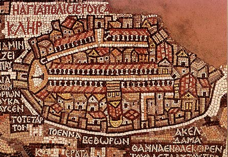
At the very end of the 19th century the ruins of an early 7th century Byzantine church were designated as the site of a new church and part of the basic work was already in train. When it came time to lay the floor, preparatory work uncovered an extensive mosaic map of the Holy Land which covered a large part of the old floor. Many biblical sites are identifiable either pictorially - such as Mamre, indicated by the picture of an oak, or terebinth tree, or by name - like Acco, Ashkelon and many others. Of overwhelming interest is the "map" of Jerusalem which is a conspicuous element in the mosaic. It has quite a few identifiable elements dating back to the 6th Century, showing, for example, a clear representation of the double-colonnaded cardus maximus from the time of Justinian; Constantine the Great's Church of the Holy Sepulchre, topographically correct, fronting on to the cardo with the steps leading up to the triportico entrance quite clearly seen; the Nea Theotokos Church, built by Justinian, at the southern end of the cardo is also clearly discernable; also clearly recognisable is the two-dimentional column, just inside the Damascus gate. This column was erected initially by the Romans to measure distances from the city. Later, when the Empire became Christianized under Constantine, a statue of Jesus was placed on top. The Damascus Gate is still, today, called in Arabic "Bab el-Amud" - the Gate of the Column! - All these to name just a few. Just outside the city wall, in the bottom right (where Mt. Zion is today), are the Greek words "Acel Dama "fields of blood" - the traditional site purchased as a burial ground for the destitute with the "blood-money" returned by Judas Iscariot. All these elements, together with the cardus secundus (with only a single line of columns to indicate its inferior importance), today's Ha-Gai Street, running from the Damascus Gate, at an angle all the way down to the Western Wall, along, in effect, the Tyropean Valley - can be identified in the map. No vestige remains, or is depicted of the Temple, or even the Temple Mount: the Byzantine Empire would have shown no interest in Jewish "memoribilia" - especially under Constantine - and the Temple Mount was to remain a wasteland - as Hadrian had made it in 135 CE except for his pagan temple to Jupiter - until the coming of Islam in 638. The Greek name for Jerusalem - Hagiapolishieroyc[almi] "Holy City of Jerusalem" is clearly seen just outside the north eastern corner of the city.